VæSSA or “VAE for Sri Lanka: a Satellite-based flood Analysis” supports the World Bank and Sri Lankan authorities through satellite based EO products in the context of climate risk mitigation.
VæSSA is a project of nazka mapps and RSS, carried out under the VAE programme and funded by the European Space Agency.
Our Services
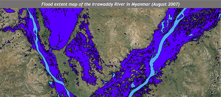
Historical Flood Mapping
Historical Flood Mapping
For effective climate change flood risk mitigation, hazard maps need to be established based on (flood) risk models. For the calibration and validation of the latter, qualitative information on past flood extents is important. The conventional means to record hydrological parameters of a flood often fail to record the spatial extent of an extreme event. The “historical flood mapping” service of VæSSA helps this through the development of a flood database (collection of flood extent maps) based on historical Earth Observation data.
Service specifications
The spatial resolution is in the range of a few meters (5–30m) depending on the satellite data, resulting in flood extent maps with a MMU of 0.5-0.05ha. A large series of all-weather radar but also optical imagery on flood events over the river basin will be needed. The temporal resolution is in the range of days.
The output is a collection (database) of flood extent layers showing the flooded areas at a given period in time (time of image acquisition) and for different flood events. These flood extent layers are vector-format and have a thematic accuracy of at least 80% to 90%.
Benefits & use
The service “historical flood mapping” provides valuable information to support risk- and water resource management in the context of flood prevention and climate risk mitigation. Concretely, the service is a valuable asset for the calibration and validation of (flood) risk models.
Moreover, EO is also an effective method to communicate potential risks, hence to influence the dialogue with the stakeholders to convey the importance of prevention and/or mitigation efforts.
Land Use/Land Cover & DEM
Land use / Land cover (change) & DEM
Besides a better characterisation of flood hazards, also the exposure of assets (crops, buildings, roads, etc.) to extreme flood events can be quantified through EO data. The VæSSA service “Land use/land cover (change) & DEM” provides valuable information on (changes in) land use/land cover, since unregulated urban sprawl or deforestation can cause frequent occurrence of floods. Precise Digital Elevation Models (DEM) additionally provide height information as an input for flood modelling, quantifying water depths and estimating flood risk.
Service specification: land cover change
An assessment of historical and recent land cover and land use (LCLU) and its change is important geo-information for disaster risk management and mitigation. A comparison of the historical LCLU in the project area with the recent LCLU provides information on spatially explicit environmental and human impacts and related risks of natural disasters. The spatial resolution of the EO data is in the range of a few meters (5–20m), depending on the satellite data, resulting in LCLU maps for the periods 1990, 2000 and 2012 with a MMU of 0.2-0.01ha. These maps are vector-format and have a thematic accuracy of at least 80%.
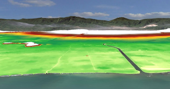
Service specification: precise DEM
Under the project ‘Improving Climate Resilience in Sri Lanka’, a flood modeling will be carried out for selected high risk basins by the World Bank and local authorities. To support the hydrologic-hydraulic assessment of flood hazards, a DEM for two river catchments will be provided with a spatial grid of at least 30 m with a mean vertical accuracy of ±15m.
In addition, a precise DEM for the area of the capital Colombo will be created based on very high-resolution tri-stereo Pléiades satellite imagery with a spatial grid of 1m and a mean vertical accuracy of up to ±2m.
Benefits & use
The “land use/land cover” maps can be used for flood modelling as a roughness layer, but also for planning purposes in all phases of a crisis. A major benefit is its large scale, providing project area wide relevant information on LCLU change, e.g. pinpointing high-value agriculture or infrastructure to be protected for floods.
Regional hydrological modelling requires precise geo-information as input to improve flood models. Whereas regionally adjusted medium-resolution DEMs are useful for modelling large catchments, very precise high-resolution DEMs significantly improve flood risk modelling at a local level. The benefits of such precise DEM will be demonstrated in VæSSA in the context of an 3D-based crisis management.
Contact information
Feel free to contact us regarding the VæSSA project
Nicolas Dosselaere | nazka mapps | www.nazka.be nicolas[at]nazka.be | +32477260434
Jonas Franke | RSS GmbH | www.rssgmbh.de franke[at]rssgmbh.de | +498948954766